Pređi na sadržaj

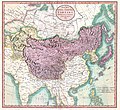
Датотека:1806 Cary Map of Tartary or Central Asia - Geographicus - Tartary-cary-1806.jpg

Sadržaj stranice nije podržan na drugim jezicima
Ovo je datoteka sa Vikimedijine ostave
S Vikipedije, slobodne enciklopedije

Originalna datoteka(5.000 × 4.569 piksela, veličina datoteke: 8,57 MB, MIME tip: image/jpeg)

John Cary: A New Map of Mongolian & Independent Tartary , From the Latest Authorities.   (Wikidata search (Cirrus search) Wikidata query (SPARQL)  Create new Wikidata item based on this file)
Umetnik
John Cary  (–1835)  wikidata:Q3446124 s:en:Author:John Cary
 
Druga imena
J. Cary
Opis kartograf, bakrorezac, mapseller, printseller i grafički umetnik
Datum rođenja/smrti 23. februar 1755. / 1754 Уреди на Википодацима 16. avgust 1835. Уреди на Википодацима
Mesto rođenja/smrti Corsley Mortlake
Period rada 1788 / 1793 / 1797 Уреди на Википодацима
Mesto rada
Normativna kontrola
artist QS:P170,Q3446124
Naslov
A New Map of Mongolian & Independent Tartary , From the Latest Authorities.
Opis
English: An exceptionally beautiful example of John Cary’s important 1806 map of Mongolian and Independent Tartary. Covers Central Asia from the Caspian Sea to Japan, extends as far north as the Obskaia Sea and as far south as India, Burma and the Philippines. Includes the modern day nations of Uzbekistan, Kazakhstan, Turkmenistan, Kirgizstan, Tajikistan and Mongolia. One of Cary’s most interesting maps. Central Asia, despite hundreds of years of passing trade on the Silk Routes, was still, at the turn of the century a largely unknown land. Cary attempts to show some of the Silk Route passages, especially to the north of the Gobi, but ultimately admits, “The Geography of these parts is extremely obscure.” All in all, one of the most interesting and few maps of Central Asia to appear in first years of the 19th century. Prepared in 1806 by John Cary for issue in his magnificent 1808 New Universal Atlas. (NOTE: The reproduction of the colors in this map appear to be incorrect, as Japan and Tibet were never part of Chinese Tartary yet appear to be the same color as it.)
Datum 1806 (dated)
Dimenzije visina: 18,5 in (46,9 cm); širina: 20 in (50,8 cm)
dimensions QS:P2048,18.5U218593
dimensions QS:P2049,20U218593
Popisni broj
Geographicus link: Tartary-cary-1806
Izvor/fotograf

Cary, John, Cary's New Universal Atlas, containing distinct maps of all the principal states and kingdoms throughout the World. From the latest and best authorities extant. London: Printed for J. Cary, Engraver and Map-seller, No. 181, near Norfolk Street, Strand, 1808.

Dozvola
(Ponovno korišćenje ove datoteke)
Ова слика је верна дигитализација оригиналног дводимензионалног уметничког дела. Ово уметничко дело је у јавном власништву из следећих разлога:
Public domain

Овај рад је такође у јавном власништву у државама са роком ауторства за живота аутора плус 100 година или мање.


Морате такође ставити ознаку за јавно власништво у Сједињеним Државама да би се знало зашто је овај рад у јавном власништву у Сједињеним Државамa.
Званичан став Задужбине Викимедије је да „верне дигитализације дводимензионалних уметничких дела која су у јавном власништву, су такође у јавном власништву”.
Стога су фотографске репродукције у јавном власништву у Сједињеним Државама. Имајте на уму да зависно од државе у којој живите поновно коришћење овог садржаја можда забрањено или ограничено. За више информација погледајте Commons:Reuse of PD-Art photographs.
Ostale verzije
Annotations
InfoField
This image is annotated: View the annotations at Commons

Natpisi

Dodajte objašnjenje u jednom redu o tome šta ova datoteka predstavlja

Stavke prikazane u ovoj datoteci

prikazuje

geografska karta Serbian (transliteracija)

engleski jezik Serbian (transliteracija)

kontrolna suma Serbian (transliteracija)

3d7f1be3ae7a9539d26d91394bee37e7dc951779

veličina podatka Serbian (transliteracija)

8.990.511 bajt

visina Serbian (transliteracija)

4.569 piksel

širina Serbian (transliteracija)

5.000 piksel

Istorija datoteke

Kliknite na datum/vreme da biste videli tadašnju verziju datoteke.

Datum/vremeMinijaturaDimenzijeKorisnikKomentar
trenutna10:56, 19. avgust 2019.Minijatura za verziju na dan 10:56, 19. avgust 2019.5.000 × 4.569 (8,57 MB)SoerfmBrightness, color
12:56, 22. mart 2011.Minijatura za verziju na dan 12:56, 22. mart 2011.5.000 × 4.569 (7,81 MB)BotMultichillT{{subst:User:Multichill/Geographicus |link=http://www.geographicus.com/P/AntiqueMap/Tartary-cary-1806 |product_name=1806 Cary Map of Tartary or Central Asia |map_title=A New Map of Chinese & Independent Tartary , From the Latest Authorities. |description=

Sledeća stranica koristi ovu datoteku:

Globalna upotreba datoteke

Drugi vikiji koji koriste ovu datoteku:

Metapodaci