
Датотека:1975 map of canal system in Lowell, Massachusetts.png
Veličina ovog prikaza: 800 × 534 piksela. 6 drugih rezolucija: 320 × 214 piksela | 640 × 428 piksela | 1.024 × 684 piksela | 1.280 × 855 piksela | 2.560 × 1.710 piksela | 3.371 × 2.252 piksela.
Originalna datoteka (3.371 × 2.252 piksela, veličina datoteke: 1,95 MB, MIME tip: image/png)
| Ovo je datoteka sa Vikimedijine ostave. Informacije sa njene stranice sa opisom prikazane su ispod. Vikimedijina ostava je skladište slobodno licenciralnih multimedijalnih datoteka. I Vi možete da pomognete. |
Opis izmene
| Opis |
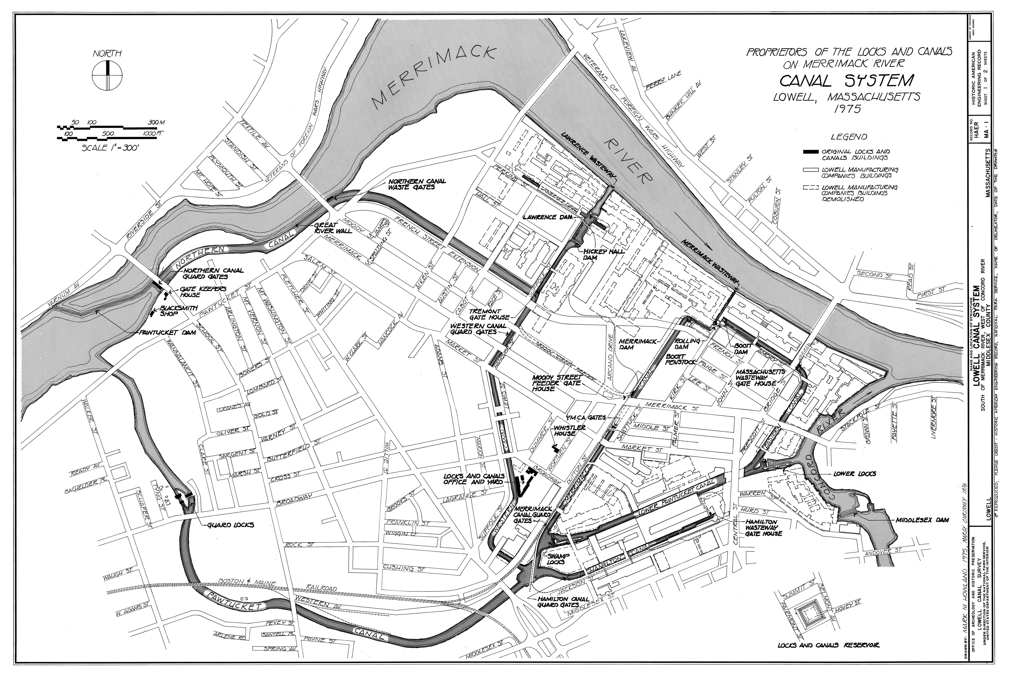
English: Canal system in Lowell, Massachusetts. Map as of 1975. |
|||||||||
| Izvor |
Lowell Canal System, Merrimack & Concord Rivers, Lowell, Middlesex County, MA, Historic American Engineering Record (Library of Congress), drawing 1. Image cropped to remove white space
|
|||||||||
| Tvorac |
Mark M. Howland, Margy Chrisney |
|||||||||
| Poreklo | Historic American Engineering Record, National Park Service, Mark M. Howland and Margy Chrisney, 1975 | |||||||||
| Dozvola (Ponovno korišćenje ove datoteke) |
|
|||||||||
| Geotemporal data | ||||||||||
| Prikaz se dešava u vremenu | ||||||||||
| Razmera | 1:3600 | |||||||||
| Heading |
 |
|||||||||
| Bounding box |
|
|||||||||
| Georeferencing | ||||||||||
| Bibliographic data | ||||||||||
| Map sheet | 1 | |||||||||

Istorija datoteke
Kliknite na datum/vreme da biste videli tadašnju verziju datoteke.
| Datum/vreme | Minijatura | Dimenzije | Korisnik | Komentar | |
|---|---|---|---|---|---|
| trenutna | 05:12, 30. mart 2011. | | 3.371 × 2.252 (1,95 MB) | Mikhail Ryazanov | 25% of the original size (to fit into 12.5 Mpix limit) |
| 05:02, 30. mart 2011. |  | 13.485 × 9.006 (2,5 MB) | Mikhail Ryazanov | {{Information |Description ={{en|1=Canal system in Lowell, Massachusetts. Map as of 1975.}} |Source =Lowell Canal System, Merrimack & Concord Rivers, Lowell, Middlesex County, MA, Historic American Engineering Record (Library of Congress), draw |
Upotreba datoteke
Sledeća stranica koristi ovu datoteku:
Globalna upotreba datoteke
Drugi vikiji koji koriste ovu datoteku:
- Upotreba na de.wikipedia.org
- Upotreba na en.wikipedia.org
- Upotreba na eo.wikipedia.org
- Upotreba na sh.wikipedia.org
- Upotreba na www.wikidata.org