
Датотека:Alpha Regio 3D.jpg

Originalna datoteka (5.000 × 4.000 piksela, veličina datoteke: 4,35 MB, MIME tip: image/jpeg)
| Ovo je datoteka sa Vikimedijine ostave. Informacije sa njene stranice sa opisom prikazane su ispod. Vikimedijina ostava je skladište slobodno licenciralnih multimedijalnih datoteka. I Vi možete da pomognete. |
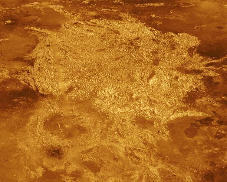
A portion of Alpha Regio is displayed in this three-dimensional perspective view of the surface of Venus. Alpha Regio, a topographic upland approximately 1300 kilometers across, is centered on 25 degrees south latitude, 4 degrees east longitude. In 1963, Alpha Regio was the first feature on Venus to be identified from Earth-based radar. The radar-bright area of Alpha Regio is characterized by multiple sets of intersecting trends of structural features such as ridges, troughs, and flat-floored fault valleys that, together, form a polygonal outline. Directly south of the complex ridged terrain is a large ovoid-shaped feature named Eve. The radar-bright spot located centrally within Eve originally marked the location of the prime meridian of Venus, but the after the Venera missions, the prime meridian was redefined to pass through the peak at the center of the crater Ariadne. Magellan synthetic aperture radar data is combined with radar altimetry to develop a three-dimensional map of the surface. Ray tracing is used to generate a perspective view from this map. The vertical scale is exaggerated approximately 23 times. Simulated color and a digital elevation map developed by the U. S. Geological Survey are used to enhance small scale structure. The simulated hues are based on color images recorded by the Soviet Venera 13 and 14 spacecraft. The image was produced at the JPL Multimission Image Processing Laboratory by Eric De Jong, Jeff Hall, and Myche McAuley, and is a single frame from the movie released at the March 5, 1991, press conference.
- image source: http://photojournal.jpl.nasa.gov/catalog/PIA00481
| Ова датотека је у јавном власништву зато што је њен аутор НАСА. НАСА-а политика ауторских права наводи „Материјали НАСА-е нису заштићени ауторским правима осим ако није другачије наведено“. (Погледајте Template:PD-USGov, NASA copyright policy page или JPL Image Use Policy.) | ||
 |
Упозорења:
|
Istorija datoteke
Kliknite na datum/vreme da biste videli tadašnju verziju datoteke.
| Datum/vreme | Minijatura | Dimenzije | Korisnik | Komentar | |
|---|---|---|---|---|---|
| trenutna | 00:10, 2. septembar 2005. | | 5.000 × 4.000 (4,35 MB) | Bricktop | larger |
| 23:41, 28. avgust 2005. |  | 645 × 516 (60 kB) | Lotse | * '''Original Caption Released with Image:''' A portion of Alpha Regio is displayed in this three-dimensional perspective view of the surface of Venus. Alpha Regio, a topographic upland approximately 1300 kilometers across, is centered on 25 degrees south |
Upotreba datoteke
2 sledeće stranice koriste ovu datoteku:
Globalna upotreba datoteke
Drugi vikiji koji koriste ovu datoteku:
- Upotreba na ar.wikipedia.org
- Upotreba na bn.wikipedia.org
- Upotreba na ca.wikipedia.org
- Upotreba na cs.wikipedia.org
- Upotreba na de.wikipedia.org
- Upotreba na en.wikipedia.org
- Upotreba na es.wikipedia.org
- Upotreba na fi.wikipedia.org
- Upotreba na fr.wikipedia.org
- Upotreba na gl.wikipedia.org
- Upotreba na hi.wikipedia.org
- Upotreba na hy.wikipedia.org
- Upotreba na it.wikipedia.org
- Upotreba na ja.wikipedia.org
- Upotreba na lb.wikipedia.org
- Upotreba na lt.wikipedia.org
- Upotreba na nds.wikipedia.org
- Upotreba na nl.wikipedia.org
- Upotreba na nn.wikipedia.org
- Upotreba na no.wikipedia.org
- Upotreba na pl.wikipedia.org
- Upotreba na pt.wikipedia.org
- Upotreba na ru.wikipedia.org
- Upotreba na sk.wikipedia.org
- Upotreba na uk.wikipedia.org
- Upotreba na www.wikidata.org
- Upotreba na zh.wikipedia.org