Pređi na sadržaj

Датотека:Florida STS51C-44-26.jpg

Sadržaj stranice nije podržan na drugim jezicima
Ovo je datoteka sa Vikimedijine ostave
S Vikipedije, slobodne enciklopedije

Originalna datoteka(4.095 × 4.095 piksela, veličina datoteke: 3,34 MB, MIME tip: image/jpeg)

Opis izmene

Opis
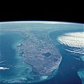
English: Florida Peninsula, January 1985
English: The Gulf of Mexico and the Gulf Stream bracket the Florida Peninsula on the west and east. The lighter shade of blue in the Gulf of Mexico is due to the much shallower (continental shelf) water depths of less than 200 feet (60 meters), whereas the much darker blue of the Gulf Stream is due to water depths in excess of 2000 feet (610 meters). Tampa Bay and Charlotte Harbor are fairly large water embayments along the west coast, and Lake Okeechobee is the large body of water in the south-central part of the state. Numerous smaller lakes can also be seen generally extending north and south through the central part of the state. Practically all of the lakes in central Florida have been created by the interaction of water with the limestone rock that underlies most of the state. Thus, through time, sinkholes have developed, occasionally swallowing houses and roads as the limestone rock collapses. This type of topography is termed "karst." Visible along the southeastern coast of Florida is a large urban area that stretches roughly from Homestead in the south to beyond West Palm Beach in the north (including the greater Miami area). This built-up area is known as the "Gold Coast" of Florida. To the west of this vibrant and ever-growing urban area is the vast, relatively uniform-looking swampland of the Everglades, which is virtually uninhabited by humans. In fact, most of the flat, saw grass landscape is occasionally interrupted by small stands of hardwood hammocks; this area is part of the Big Cypress National Preserve and the Everglades National Park. Most of the Florida Keys are visible as they form an archipelago that arcs to the southwest from the southern tip of Florida. Also visible are parallel lines of clouds that have been formed as a cool air mass from the northwest is pushed across the warmer water of the Gulf Stream. A very faint smoke plume that originates near the Georgia-South Carolina border provides a clue to the wind direction at the time this photograph was taken.
Datum
Izvor NASA Image and Video Library JSC Gateway to Astronaut Photography of Earth
Autor NASA
Camera
InfoField
Hasselblad
Focal length
InfoField
100 mm
Film
InfoField
5017: Kodak, natural color positive, Ektachrome, X Professional, ASA 64, standard base
Content Provider
InfoField
Kamlesh P. Lulla Ph.D. Chief, Earth Sciences Branch
Responsible NASA Official
InfoField
Ed Wilson
Curator
InfoField
Jaime Powell
Положај камере20° 54′ 00″ С, 79° 30′ 00″ З Kartographer map based on OpenStreetMap.Ова и друге слике снимљене у близини на: OpenStreetMapinfo
Положај објекта27° 00′ 00″ С, 81° 00′ 00″ З Kartographer map based on OpenStreetMap.Ова и друге слике снимљене у близини на: OpenStreetMapinfo
This image or video was catalogued by Johnson Space Center of the United States National Aeronautics and Space Administration (NASA) under Photo ID: STS51C-44-26 and Alternate ID: 51C-44-026.

This tag does not indicate the copyright status of the attached work. A normal copyright tag is still required. See Commons:Licensing.
Other languages:

Licenciranje

Public domain Ова датотека је у јавном власништву зато што је њен аутор НАСА. НАСА-а политика ауторских права наводи „Материјали НАСА-е нису заштићени ауторским правима осим ако није другачије наведено“. (Погледајте Template:PD-USGov, NASA copyright policy page или JPL Image Use Policy.)
Упозорења:
  • Употреба НАСА-их логотипа и емблема је ограничена Америчким законом 14 CFR 1221.
  • НАСА-ин сајт хостује велики број слика Совјетске/Руске свемирске агенције и других не-Америчких свемирских агенција. Ове слике нису нужно у јавном власништву.
  • Материјали засновани на подацима Хабл телескопа су слободни само ако је њихов аутор STScI.[1] Такође погледајте {{PD-Hubble}} и {{Cc-Hubble}}.
  • Материјали са сонде SOHO су заштићени ауторским правима и потребна је дозвола за комерцијалну употребу. [2]
  • Слике са сајта APOD можда подлежу ауторским правима. [3]

Natpisi

Dodajte objašnjenje u jednom redu o tome šta ova datoteka predstavlja
Florida Peninsula, January 1985

Stavke prikazane u ovoj datoteci

prikazuje

Florida Serbian (transliteracija)

Atlantski okean Serbian (transliteracija)

Meksički zaliv Serbian (transliteracija)

Florida Keys English

horizont Serbian (transliteracija)

STS-51-C English

NASA Serbian (transliteracija)

20°54'N, 79°30'W

26. januar 1985

izvor datoteke Serbian (transliteracija)

rukovalac Serbian (transliteracija): NASA Serbian (transliteracija)

žižna daljina Serbian (transliteracija)

100 milimetar

koordinate prikazanog mesta Serbian (transliteracija)

27°N, 81°W

Istorija datoteke

Kliknite na datum/vreme da biste videli tadašnju verziju datoteke.

Datum/vremeMinijaturaDimenzijeKorisnikKomentar
trenutna15:24, 14. februar 2021.Minijatura za verziju na dan 15:24, 14. februar 2021.4.095 × 4.095 (3,34 MB)AskeuhdHigher resolution version
11:25, 1. septembar 2005.Minijatura za verziju na dan 11:25, 1. septembar 2005.640 × 608 (80 kB)Roger469 == Fonte == Earth.Jonhson Space Center.National Aeronautic and Space Administration.government/Space Shuttle Earth Observations Photography/Earth From Space/low resolution.[ http://earth.jsc.nasa.gov/sseop/efs/lores.pl?PHOTO= STS51C-44-26 Florida – Cal

Sledeća stranica koristi ovu datoteku:

Globalna upotreba datoteke

Drugi vikiji koji koriste ovu datoteku: