
Датотека:Iceland Mid-Atlantic Ridge map.svg

Veličina PNG pregleda za ovu SVG datoteku je 376 × 390 piksela. 5 drugih rezolucija: 231 × 240 piksela | 463 × 480 piksela | 740 × 768 piksela | 987 × 1.024 piksela | 1.974 × 2.048 piksela.
Originalna datoteka (SVG datoteka, nominalno 376 × 390 piksela, veličina: 129 kB)
| Ovo je datoteka sa Vikimedijine ostave. Informacije sa njene stranice sa opisom prikazane su ispod. Vikimedijina ostava je skladište slobodno licenciralnih multimedijalnih datoteka. I Vi možete da pomognete. |
Opis izmene
| Opis | |
| Datum | |
| Izvor | http://pubs.usgs.gov/gip/dynamic/understanding.html |
| Autor | http://pubs.usgs.gov/gip/dynamic/understanding.html |
| Ostale verzije |
|


Licenciranje
This image is in the public domain in the United States because it only contains materials that originally came from the United States Geological Survey, an agency of the United States Department of the Interior. For more information, see the official USGS copyright policy.
|
| Annotations | This image is annotated: View the annotations at Commons |
Istorija datoteke
Kliknite na datum/vreme da biste videli tadašnju verziju datoteke.
| Datum/vreme | Minijatura | Dimenzije | Korisnik | Komentar | |
|---|---|---|---|---|---|
| trenutna | 20:48, 10. januar 2014. | | 376 × 390 (129 kB) | Amitchell125 | text improved |
| 16:42, 26. februar 2010. |  | 376 × 390 (68 kB) | Beao | Tweak. | |
| 16:40, 26. februar 2010. |  | 376 × 390 (68 kB) | Beao | Tweak. | |
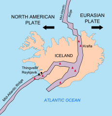
| 16:37, 26. februar 2010. |  | 376 × 390 (68 kB) | Beao | == Summary == {{Information |Description={{en|1=Map showing the Mid-Atlantic Ridge splitting Iceland and separating the North American and Eurasian Plates. The map also shows Reykjavik, the capital of Iceland, the Thingvellir area, and the locations of so |
Upotreba datoteke
Sledeća stranica koristi ovu datoteku:
Globalna upotreba datoteke
Drugi vikiji koji koriste ovu datoteku:
- Upotreba na be-tarask.wikipedia.org
- Upotreba na bn.wikipedia.org
- Upotreba na ca.wikipedia.org
- Upotreba na en.wikipedia.org
- Upotreba na en.wikivoyage.org
- Upotreba na fi.wikipedia.org
- Upotreba na hr.wikipedia.org
- Upotreba na id.wikipedia.org
- Upotreba na it.wikipedia.org
- Upotreba na ko.wikipedia.org
- Upotreba na lb.wikipedia.org
- Upotreba na nl.wikipedia.org
- Upotreba na no.wikipedia.org
- Upotreba na pl.wikipedia.org
- Upotreba na simple.wikipedia.org
- Upotreba na sl.wikipedia.org
- Upotreba na sv.wikipedia.org
- Upotreba na tr.wikipedia.org
- Upotreba na uk.wikipedia.org
- Upotreba na zh.wikipedia.org
- Upotreba na zh.wikivoyage.org