Pređi na sadržaj

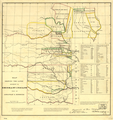
Датотека:Map of Indian territory 1836.png

Sadržaj stranice nije podržan na drugim jezicima
Ovo je datoteka sa Vikimedijine ostave
S Vikipedije, slobodne enciklopedije

Originalna datoteka (7.477 × 9.136 piksela, veličina datoteke: 92,32 MB, MIME tip: image/png)

Opis izmene

Warning The original file is very high-resolution. It might not load properly or could cause your browser to freeze when opened at full size. Open in ZoomViewer
Opis
English: 1836 map showing the lands assigned to emigrant Indians west of Arkansas and Missouri of the Indian Territory jurisdiction — in the U.S. From: [Documents concerning Col. Henry Dodge's expedition to the Rocky Mountains], House Document 181, 24th Cong., 1st session, 1835-36, serial 289.
Datum
Izvor https://www.loc.gov/item/99446197/
Autor A Jones, Adj. Genl. Topographic Bureau
Dozvola
(Ponovno korišćenje ove datoteke)
This image is available from the United States Library of Congress's Prints and Photographs division
under the digital ID missing.
This tag does not indicate the copyright status of the attached work. A normal copyright tag is still required. See Commons:Licensing.

العربية  беларуская (тарашкевіца)  বাংলা  čeština  Deutsch  English  español  فارسی  suomi  français  galego  עברית  magyar  Bahasa Indonesia  italiano  日本語  Bahaso Melayu Jambi  lietuvių  македонски  മലയാളം  Nederlands  polski  português  português do Brasil  română  русский  sicilianu  slovenčina  slovenščina  Türkçe  українська  中文  中文(简体)  中文(繁體)  +/−

Licenciranje

Public domain

Овај рад је такође у јавном власништву у државама са роком ауторства за живота аутора плус 70 година или мање.


Морате такође ставити ознаку за јавно власништво у Сједињеним Државама да би се знало зашто је овај рад у јавном власништву у Сједињеним Државамa.
Utvrđeno je da ova datoteka nije ograničena u pogledu autorskih prava, uključujući i sva srodna i susedna prava.

Prvobitan dnevnik otpremanja

The original description page was here. All following user names refer to en.wikipedia.
  • 2005-01-11 05:53 CPret 698×744×8 (670317 bytes) Map of Indian territory - 1836

Natpisi

Dodajte objašnjenje u jednom redu o tome šta ova datoteka predstavlja

Stavke prikazane u ovoj datoteci

prikazuje

status autorskog prava Serbian (transliteracija)

javno vlasništvo Serbian (transliteracija)

23. februar 1836Gregorijanski

veličina podatka Serbian (transliteracija)

96.808.365 bajt

visina Serbian (transliteracija)

9.136 piksel

širina Serbian (transliteracija)

7.477 piksel

kontrolna suma Serbian (transliteracija)

e7b16b400e660a7a0591028feee2b766787e1076

Istorija datoteke

Kliknite na datum/vreme da biste videli tadašnju verziju datoteke.

Datum/vremeMinijaturaDimenzijeKorisnikKomentar
trenutna16:31, 5. mart 2018.Minijatura za verziju na dan 16:31, 5. mart 2018.7.477 × 9.136 (92,32 MB)Ww2censorHigher resolution from source converted from jpg to png
22:37, 6. april 2008.Minijatura za verziju na dan 22:37, 6. april 2008.698 × 744 (655 kB)File Upload Bot (Magnus Manske) {{BotMoveToCommons|en.wikipedia}} {{Information |Description={{en|Map of Indian territory - 1836 '''Source:''' Image is from the [http://memory.loc.gov/ammem/gmdhtml/gmdhome.html Library of Congress] and is in the public domain.<br> '''Area:''' 698x744

Sledeća stranica koristi ovu datoteku:

Globalna upotreba datoteke

Drugi vikiji koji koriste ovu datoteku:

Metapodaci